
Faster and Easier Mapping for Fixed and Mobile Network Performance Map Tiles
When we first offered our open performance datasets to the public in 2020, Ookla®’s main priorities were to make sure that our fixed and mobile network performance data would be accessible, relevant, and useful to those researching or trying to improve the state of networks worldwide. As conversations around connectivity continue to evolve, so too has our open dataset. For instance, earlier this year we extended our open performance dataset to include additional responsiveness insights by showing latency under load for both saturated downlink and uplink measurements.
As we continue to advance our datasets to include more new, exciting, and relevant metrics, we remain committed to ensuring that key data views are accessible to as many interested parties as possible: more people accessing network performance and consumer quality of experience insights means more important conversations surrounding connectivity and ultimately better public policy to help improve broadband access globally. This is why we are excited to announce the addition of centroid coordinates to our open data.
What are centroids?
So what exactly are centroid coordinates, and how do they help provide more access to our data? Centroids are the point where the medians of a shape intersect. Or, to put it simply, a centroid is the center point of a shape. For more in-depth information on the math behind how centroids are computed, check out RPubs documentation on the subject.
Why centroids are important
The Ookla for Good open dataset makes use of spatial tiles. While the geometries of tiles provide precision in mapping, working with and plotting spatial data can often be a long and arduous process. This issue is further compounded by the global nature of our datasets, making it difficult for users to subset specific areas to look at. Machines with limited RAM may take multiple hours to do a single spatial join to a small area, and if more metrics are added, the joins take longer and longer to run.
The addition of centroid coordinates means that rather than needing a geospatial toolset, users can filter to an approximation of their area of interest using a numerical bounding box. This will dramatically cut down on the time to join our data to other data sources, improving accessibility for those looking to work with Ookla’s Fixed and Mobile Network Performance Map Tiles.
Mapping open data using centroid coordinates
For this example let’s use the country of Brazil to demonstrate one way of mapping our open data with centroid coordinates in R.
library(geobr)
library(ggrepel)
# remotes::install_github("teamookla/ooklaOpenDataR")
library(ooklaOpenDataR)
library(scales)
library(sf)
library(tidyverse)
library(usethis)

# Set global defaults
theme_set(theme_minimal())
theme_update(text = element_text(color = "#181512"))
theme_update(plot.subtitle = element_text(hjust = 0.5))

# plot colors
purple <- "#8D5DB2"
light_gray <- "#EDEAE6"
mid_gray <- "#9B9893"

colPal <- colorRampPalette(c("#E4AECF", "#3E0E1C"))
I am using the package geobr to grab the geometries for the country. There are multiple functions within this package that allow you to grab geometries at different administrative levels if you want to follow this tutorial for a smaller portion of the country.
We will be using st_bbox() to create a bounding box to help subset the performance map tiles. An alternative to this is to get min/max coordinates from searching online (for ex: google “Brazil bounding box”). We highlighted the dimensions for Brazil’s bounding box on the following map.
#Set up map
brazil <- read_country(year=2020) %>%
  st_transform(4326)

br_bbox <- brazil %>% # use to subset open data
  st_bbox()

ggplot(brazil) +
  geom_sf(color = mid_gray, fill = light_gray, lwd = 0.08) +
  labs(title = "Brazil") +
  geom_text_repel(aes(label = name_state, geometry = geom),
    family = "sans",
    color = dark_gray,
    size = 2.2,
    stat = "sf_coordinates",
    min.segment.length = 2
  ) +
  theme(
    panel.grid.major = element_blank(),
    panel.grid.minor = element_blank(),
    axis.text = element_blank(),
    axis.title = element_blank()
  ) +
  annotate(geom = "rect", ymax = 5.27, ymin = -33.75, xmax = -28.85, xmin = -73.99, colour = purple, fill = colorspace::lighten("#8D5DB2", 0.5), alpha = 0.1)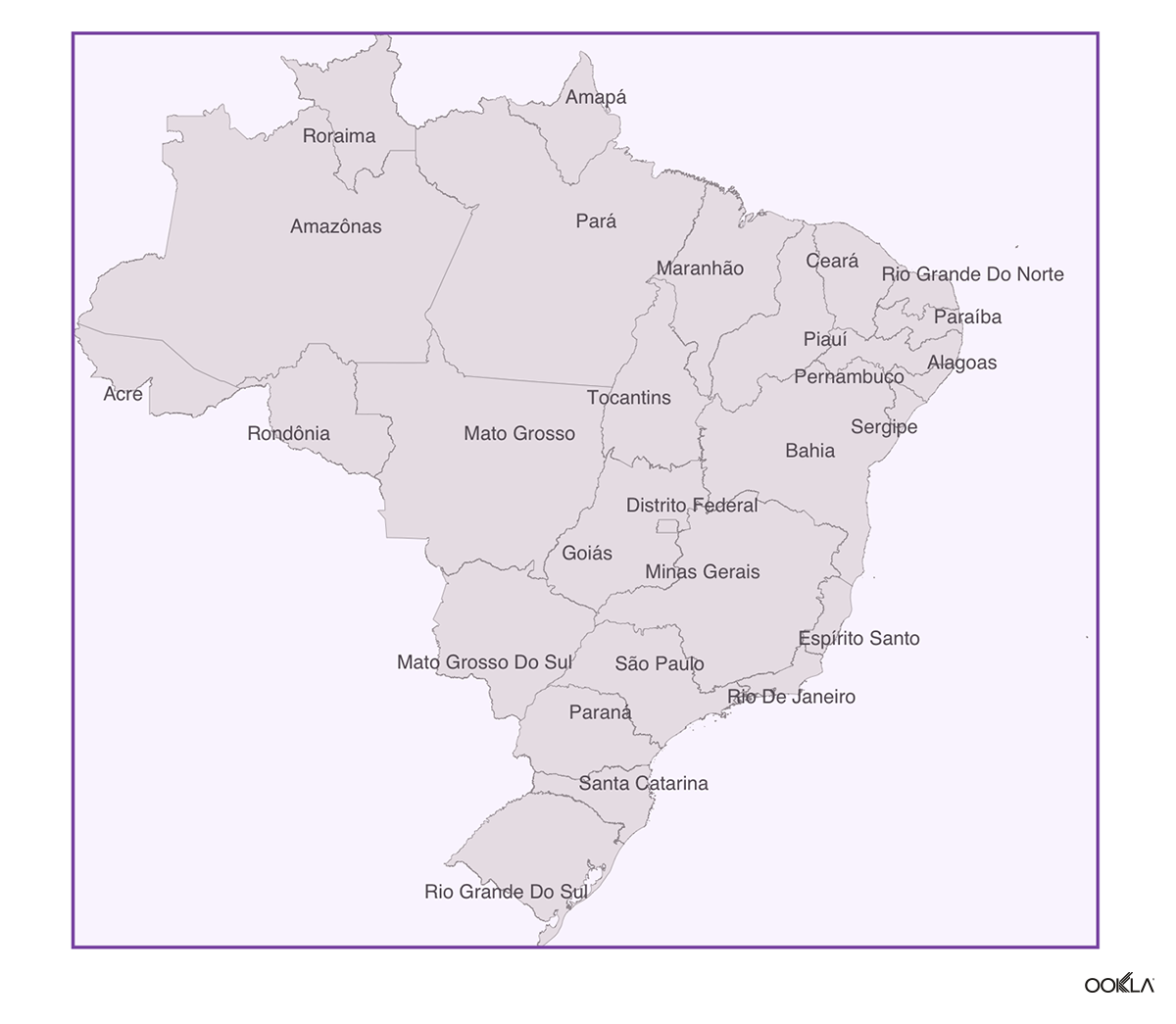
We will then download the performance map tiles using the OoklaOpenDataR package, and then subset the global data to make it more manageable to work with when we do our join.
fixed_br_q2 <- get_performance_tiles(service = "fixed", quarter = 2, year = 2023) %>%
  filter(tile_y <= br_bbox['ymax'], tile_y >= br_bbox['ymin'], tile_x <= br_bbox['xmax'], tile_x >= br_bbox['xmin']) %>%
  st_as_sf(wkt = "tile", crs = 4326)
You can then check to see what the remaining data looks like. There will be points outside of the boundaries, but that is to be expected.
ggplot(brazil) + # Check
  geom_sf(color = mid_gray, fill = light_gray, lwd = 0.08) +
  geom_sf(data = fixed_br_q2, color = purple) +
  labs(
    title = "Brazil",
    subtitle = "Ookla® Open Data Fixed Tiles | Q2 2023"
  ) +
  geom_text_repel(aes(label = name_state, geometry = geom),
    family = "sans",
    color = dark_gray,
    size = 2.2,
    stat = "sf_coordinates",
    min.segment.length = 2
  ) +
  theme(
    panel.grid.major = element_blank(),
    panel.grid.minor = element_blank(),
    axis.text = element_blank(),
    axis.title = element_blank()
  )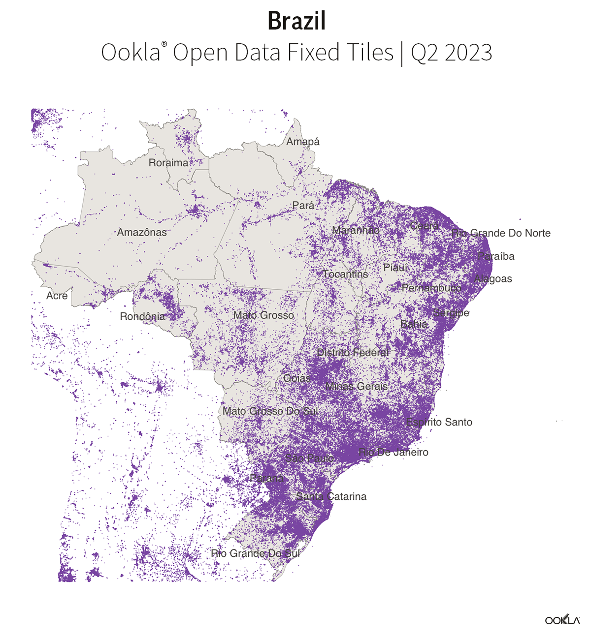
Voilà! You now have a smaller dataset that can then be used to perform analysis as needed.
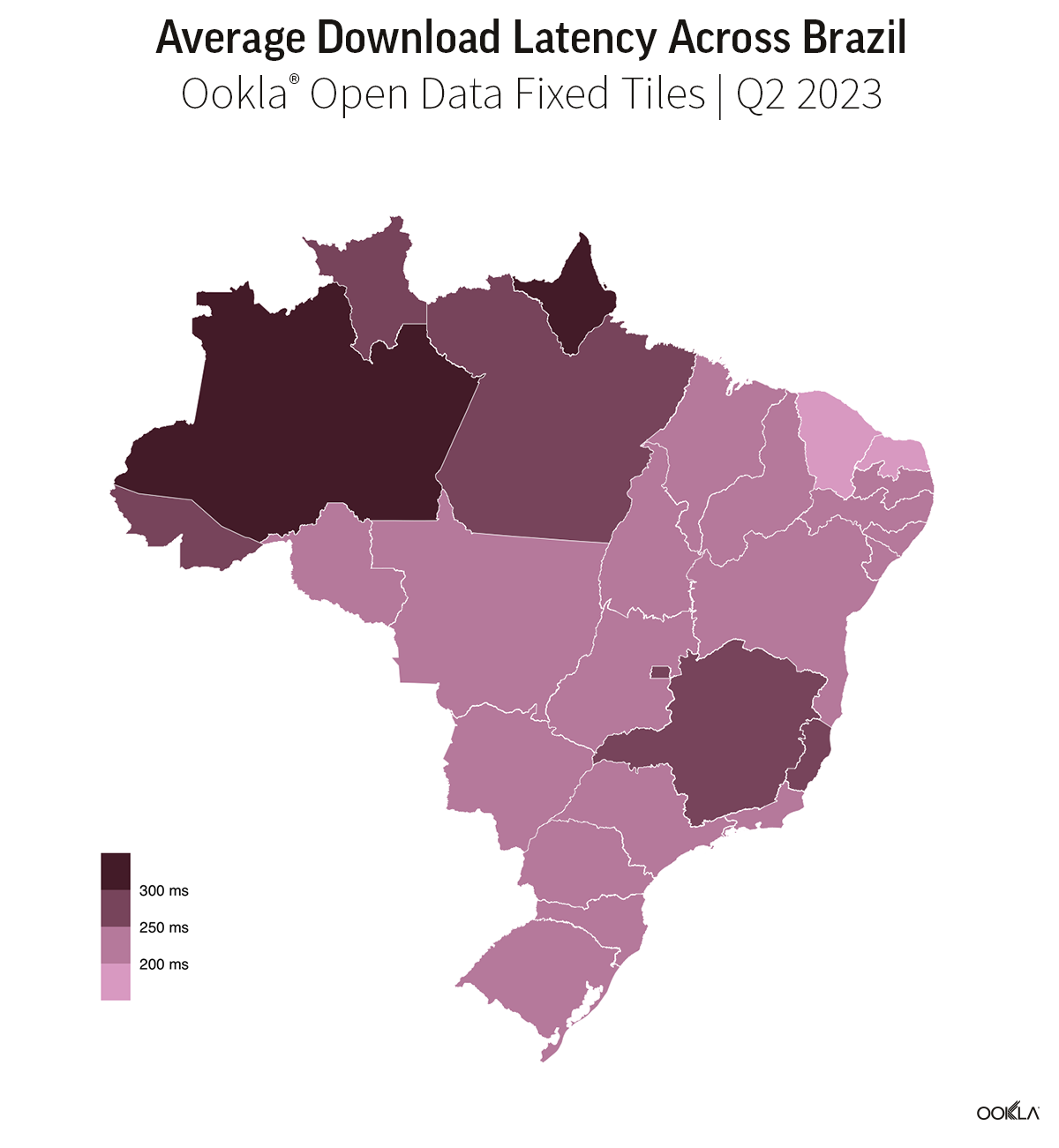
Aggregating Loaded Latency
As stated before, we announced the addition of additional loaded latency metrics to our data in January. We can use the previous code to show a simple example of how to aggregate it. For more examples and information on how to perform your own analysis on our open data check out this tutorial.
First, use the following code to perform a spatial join to get a more precise location for our tiles.
#Join
br_tiles <- brazil %>%
  st_join(fixed_br_q2, left = FALSE)
Then aggregate the data up to the desired level of granularity. In this case, we aggregated the data by states in Brazil.
br_aggs <- br_tiles %>%
  st_set_geometry(NULL) %>%
  group_by(name_state) %>%
  reframe(
    tiles = n(),
    avg_lat_download_ms = round(weighted.mean(avg_lat_down_ms, tests, na.rm = TRUE), 2),
    avg_lat_upload_ms = round(weighted.mean(avg_lat_up_ms, tests, na.rm = TRUE), 2),
    total_tests = sum(tests)
  )
Re-join the geometries from Brazil.
br_aggs <- left_join(brazil, br_aggs)And then map.
ggplot(br_aggs) +
  geom_sf(aes(fill = avg_lat_download_ms), color = "white", lwd = 0.08) +
  scale_fill_stepsn(colors = colPal(5), labels = label_number(suffix = " ms"), n.breaks = 4, guide = guide_colorsteps(title = "")) +
  theme(
    panel.grid.minor = element_blank(),
    panel.grid.major = element_blank(),
    axis.title.x = element_text(hjust = 1),
    legend.text = element_text(color = "black"),
    axis.text = element_blank()
  ) +
  labs(
    title = "Average Download Latency Across Brazil",
    subtitle = "Ookla® Open Data Fixed Tiles | Q2 2023"
  )
This example offers one way to filter with the added centroid coordinates, but it is by no means the only approach. If you are interested in exploring more ways to interact with our data, additional tutorials are available on our GitHub page.
Ookla retains ownership of this article including all of the intellectual property rights, data, content graphs and analysis. This article may not be quoted, reproduced, distributed or published for any commercial purpose without prior consent. Members of the press and others using the findings in this article for non-commercial purposes are welcome to publicly share and link to report information with attribution to Ookla.